Arapeen OHV Trail, Utah
Free Mobile phone Map
I understand the thrill and excitement that comes with exploring the Arapeen Trail, but I want to ensure your safety and peace of mind. I know it's easy to lose your way amidst the winding roads and sprawling vistas. That's why I've made it even easier to keep track of your location as you ride. No more worrying about spotty cell service!
With just a few clicks, you can download a trail map straight to your phone, giving you access to everything you need to stay on the right path. Plus, there's no need for Wi-Fi or data, so you can ride without any interruptions. It's like having your own personal trail guide at your fingertips.
Simply follow the steps below to get the map, and get ready for a truly immersive and exhilarating experience on the Arapeen Trail. Stay safe, stay adventurous!
Kevin-

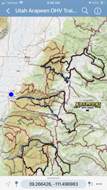
Utah Arapeen OHV Trail - Mobile Map
This topographical map tracks your position as you ride the trails. (Sanpitch OHV Trail included)
STEPS TO GET THE MOBILE MAP:
This topographical map tracks your position as you ride the trails. (Sanpitch OHV Trail included)
STEPS TO GET THE MOBILE MAP:
- Install the AVENZA MAPS App on your mobile phone- (Google Play or App Store).
- Open the app
- Click STORE icon at the bottom
- Click FIND A MAP search bar, select KEYWORDS, then type: UTAH ARAPEEN OHV TRAIL SYSTEM
- Click FREE button to download the map
- Click MY MAPS icon at the bottom to view.

Free gps dATA

GPS Data for the Arapeen OHV Trail- (Sanpitch OHV Trail included).
Data Formats:
Data Formats:
| GPS Exchange Format -.gpx |
| Garmin - .gdb |
For free software to convert the above files to other GPS formats, visit: GPS Babel.org