
20+ Free trail maps
SUGGESTED 1-DAY RIDES:
Skyline Potter's Ponds Difficulty: Easy Miles: 55 (July-Oct) Trailhead: Mt. Pleasant, Fairview, or Spring City. This OHV trail passes Huntington Reservoir, Miller Flat Reservoir, and Potter's Ponds before looping back along Skyline Drive. A great ATV ride if you like to fish along the way. Parts of this ATV trail have a 66" width restriction.
Horseshoe Mountain Summit Difficulty: Moderate Miles: 43 (July-Oct) Trailhead: Ephraim. This OHV route passes Horseshoe Mountain along Skyline Drive and descends the eastern side of the plateau past Grassy Lake. Soup Bowl and Pete's Hole Reservoirs are nearby.
Patton Trail Duck Fork Difficulty: Moderate Miles: 27-37 (June-Oct) Trailhead: Manti. The lower route rides Middle and North Fork Canyons, while the higher route loops by Cove and Duck Fork Reservoirs. Parts of this ATV trail have a 66" width restriction.
Beaver Creek Henningson Difficulty: Moderate Miles: 33-38 (July-Oct) Trailhead: Mayfield. This loop ATV ride heads up the Beaver Creek Road and connects with Skyline Drive at Gunnison Valley. There are several lakes in the area if you like to fish. The route heads north and returns to Mayfield via 12-Mile Canyon Road.
SUGGESTED MULTIPLE-DAY RIDES:
Skyline Loop 2-Day Ride Difficulty: Moderate Miles: 121 (July-Oct) This OHV route begins in Mt. Pleasant, overnights in Ephraim, and then returns to Mt. Pleasant. Parts of this ATV trail have a 66" width restriction. Contact the Forest Service before booking motels to verify Skyline Drive is open. (435) 283- 4151
High Top Loop 2-Day Ride Difficulty: Moderate Miles: 120 (July-Oct) This OHV route begins in Sterling, overnights in Manti, and then returns to Sterling. Contact the Forest Service before booking motels to verify Skyline Drive is open. (435) 283- 4151
Arapeen Trail 4-Day Circuit Ride Difficulty: Moderate Miles: 220 (July-Oct) This OHV route ends in a different town every night. Contact the Forest Service before booking motels to verify Skyline Drive is open. (435) 283- 4151
Overnight Parking Locations:
Mt. Pleasant: Contoy Arena 955 W. 1000 S.
Ephraim: 1.5 mi. up Ephraim Canyon
Manti: City Park 100 N. 350 W. or 2.1 mi. up Manti Canyon
Sterling: 1.7 mi. up Six-Mile Canyon
FAIRVIEW, UTAH OHV TRAILS:
North Skyline Fish Creek Difficulty: Easy Miles: 55 (June-Oct) A very scenic and enjoyable ATV ride at an altitude of over 9,000 feet. North Skyline Drive is a maintained gravel mt. road and is great for inexperienced OHV riders. Parts of this ATV trail have a 60" width restriction.
EPHRAIM, UTAH OHV TRAILS:
Fred's Flat Loop Difficulty: Moderate Miles: 16-28 (June-Oct) A fun ATV loop that heads up New Canyon, cuts across Fred's Flat and Left-Land Fork road, and then returns to Ephraim on the Main Canyon road. Advise: Dangerous Creek Crossing in June.
Dry Canyon Loop Difficulty: Easy Miles: 32-36 (May 15-Oct) This OHV route heads up Dry Canyon and loops back down Main Canyon to the South (32 mi.), or Wales Canyon to the North (36 mi.).
Ephraim Spring City Loop Difficulty: Easy Miles: 53 (July-Oct) This OHV ride heads up Ephraim Canyon, follows Skyline Drive north and descends down Spring City Canyon. The ride back to Ephraim is about 13 miles on OHV legal county roads.
Bald Mountain Loop Difficulty: Advanced Miles: 19 (June-Oct) Great View of Sanpete Valley. This ATV ride heads up the face of Bald Mt. and drops off into Willow Creek. The ride joins the Ephraim Canyon Road near Lake Hill Campground.
Hanging Tree Trail: 4WD Crawling Difficulty: Very Extreme (May 15-Oct)
MANTI, UTAH OHV TRAILS:
Manti Mountain Willow Creek Difficulty: Advanced Miles: 42 (June-Oct) This OHV ascends the Manti face and connects to the Ephraim Canyon Road via Willow Creek. After reaching Skyline Drive the ride heads south and returns to Manti via Lowery Fork.
Sheep Trail Loop Difficulty: Moderate Miles: 23 (June-Oct) This OHV ride begins on the historic Sheep Trail route before pasing Burnt Hill Flat. The route intersects Middle Fork Canyon and returns to Manti via North Fork.
STERLING and MAYFIELD, UTAH OHV TRAILS:
Palisade Ferron Difficulty: Moderate Miles: 40-47 (July-Oct) From Palisade State Park, this trail heads up 6-Mile Canyon to Skyline Drive. The trail then heads north and loops back to Sterling town via North Fork, Arapeen OHV Trail #38 & #39. Parts of this ATV trail have a 66" width restriction.
Heliotrope Mountain Difficulty: Easy Miles: 72 (July-Oct) This OHV ride heads up 6-Mile Canyon and loops around the south side of Heliotrope Mt. before passing Ferron Reservoir. At Skyline Drive the trail goes north and heads down Manti Canyon.
Funk Canyon Mt Musinia Difficulty: Moderate Miles: 28-39 (June-Oct) This OHV trail heads up Funk Canyon and eventually connects to 12-Mile Canyon Road. The route loops back to Sterling via North Hollow and crosses 2 State Wildlife Management Areas. Parts of this ATV trail have a 50" width restriction.
FOUNTAIN GREEN, UTAH OHV TRAILS:
Log & Maple Canyons Difficulty: Moderate Miles: 25-36 (July-Oct) This OHV trail goes up Log Hollow to the top of the Sanpitch Mountains. You will ride the spine of the range and can descent either Maple or Wales Canyon.
Big Hollow Loop Difficulty: Easy Miles: 23 (May-Nov) This low elevation OHV route is ideal to ride in the early spring when most of the other routes are still closed with snow. The highest elevation on the ride is 7,425'
OTHER OHV RIDES:
Yuba State Park OHV Trails Map (May-Nov) This map shows OHV routes that can be ridden from Yuba State Park in the Valley Mountains west of Gunnison, Utah.
Northern Gooseberry ATV Trails (June-Oct) This trail map shows how to ride from the Arapeen OHV Trail System to the Paiute ATV Trail.
Free Mobile phone Map

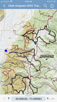
Utah Arapeen OHV Trail - Mobile Map
This topographical map tracks your position as you ride the trails. (Sanpitch OHV Trail included) STEPS TO GET THE MOBILE MAP:
|
|

Free gps dATA

GPS Data for the Arapeen OHV Trail- (Sanpitch OHV Trail included).
Data Formats:
Data Formats:
| GPS Exchange Format -.gpx |
| Garmin - .gdb |
For free software to convert the above files to other GPS formats, visit: GPS Babel.org